Subterranean Muon Tomography: Mapping Deep Earth Structures and Resource Deposits with Cosmic Ray Imaging
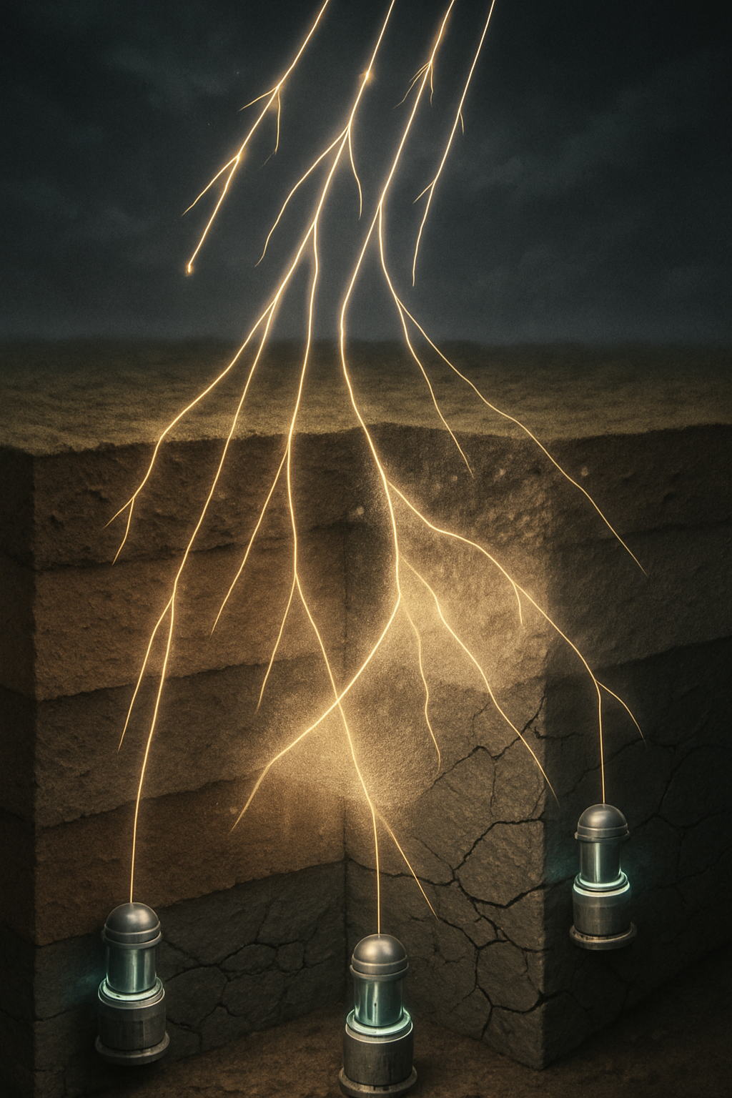
Subterranean muon tomography, also known as muography, is an emerging passive imaging technique that utilizes naturally occurring cosmic ray muons to probe the density structure of large-scale geological and man-made objects. These high-energy particles, generated from cosmic ray interactions in the upper atmosphere, continuously shower the Earth's surface. Their ability to penetrate significant depths of rock and other materials before being absorbed or scattered makes them unique probes for investigating the subsurface. By measuring the attenuation or scattering of muon flux as it traverses a target volume, scientists can create density maps, offering insights into internal structures otherwise hidden from view. This article reviews the fundamental principles of muon tomography, discusses its established applications in geosciences and related fields, and explores its speculative, yet promising, potential for mapping deeper Earth structures and identifying subterranean resource deposits.
The core advantage of muon tomography lies in its non-invasive nature and its reliance on a free, naturally abundant radiation source, eliminating the need for artificial radiation generation. This makes it particularly appealing for sensitive environments or for continuous monitoring applications. While current applications predominantly focus on relatively shallower structures (tens to hundreds of meters, occasionally kilometers of rock overburden), the ongoing advancements in detector technology, data processing algorithms, and a deeper understanding of muon physics are paving the way for exploring its capabilities at greater depths, offering a tantalizing prospect for revolutionizing how we perceive and explore the Earth's subsurface.
Fundamentals of Muon Tomography
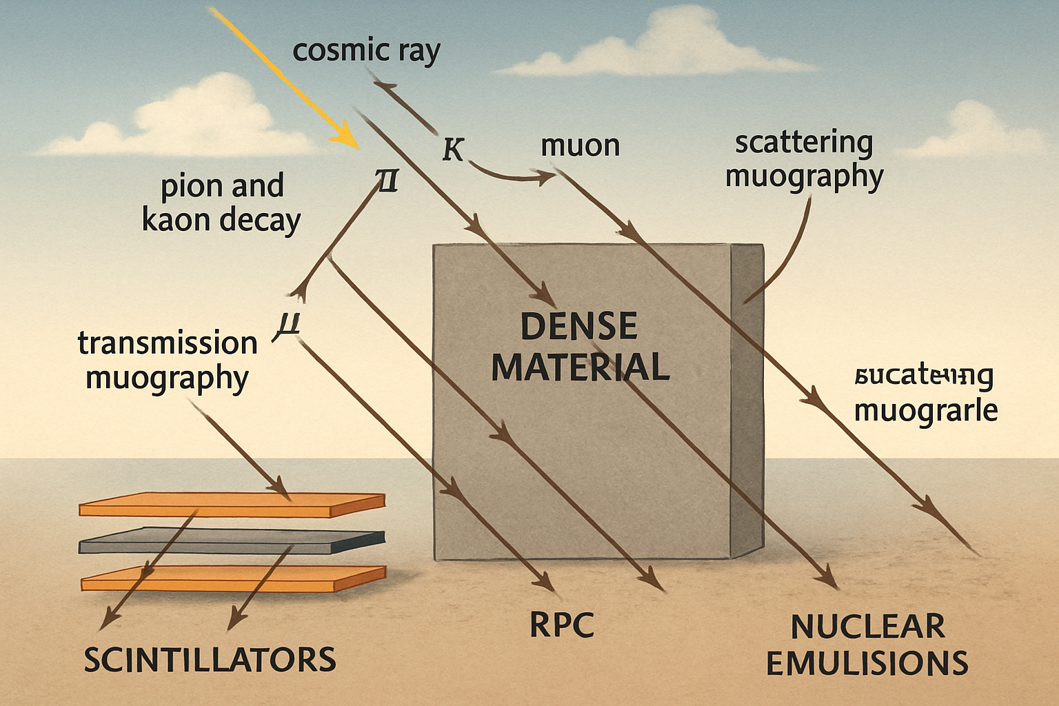
Cosmic ray muons are primarily produced through the decay of pions and kaons, which are themselves created when primary cosmic rays (mostly high-energy protons and atomic nuclei) collide with atomic nuclei in the Earth's upper atmosphere. These muons are highly energetic and relativistic, allowing them to travel significant distances through dense matter. The interaction of muons with matter is primarily governed by ionization energy loss and, at higher energies, by processes like bremsstrahlung, pair production, and photonuclear interactions. The degree to which muons are absorbed or scattered is directly related to the density and thickness of the material they traverse—higher density or greater thickness results in greater attenuation of the muon flux or larger scattering angles.
Two primary modes of muon tomography are employed: transmission muography and scattering muography. Transmission muography, analogous to X-ray radiography, measures the attenuation of the muon flux after it has passed through the target object. By comparing the measured flux with the expected open-sky flux from various directions, a 2D density map (radiograph) or, with multiple detector positions, a 3D density model can be reconstructed. Scattering muography, on the other hand, utilizes the small angular deflections muons undergo as they interact with atomic nuclei. The scattering angle is sensitive to the atomic number (Z) of the material, offering potential for material differentiation, although it is typically used for shallower targets due to the requirement of tracking muons both before and after they pass through the volume of interest. Detector technologies commonly used include scintillators coupled with photomultiplier tubes, resistive plate chambers (RPCs), and nuclear emulsion films, each with advantages in terms of resolution, cost, and field applicability.
Established Applications in Geoscience and Subsurface Imaging
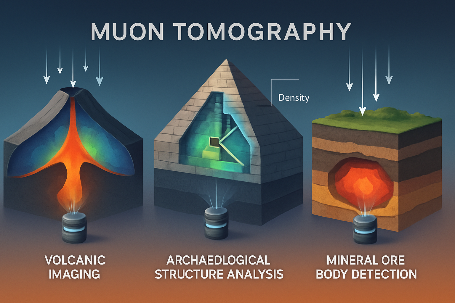
Muon tomography has found successful applications in various geoscientific and engineering domains, primarily for imaging structures at depths ranging from tens to a few hundreds of meters, with some volcanic applications extending to kilometer-scale depths of rock. Volcanology has been a particularly fruitful area, with muography used to image the internal structure of volcanoes, map magma conduits, monitor density changes associated with volcanic unrest, and understand eruptive dynamics. For instance, temporal variations in density detected by muography have provided insights into the opening of fractures and the movement of magma prior to eruptions.
Beyond volcanology, muography has been applied in archaeology for the discovery and characterization of hidden chambers in pyramids and historical structures, and for locating subterranean cavities and tunnels in civil engineering and geotechnical contexts. The mining industry is also exploring muography for delineating ore bodies, assessing rock mass stability, and potentially monitoring changes within underground mines. These applications underscore the technique's ability to provide valuable density information in complex subsurface environments non-invasively.
The Frontier: Probing Deeper Earth Structures and Resource Deposits
The primary challenge in extending muon tomography to significantly greater depths ("deep Earth" in the context of kilometers to tens of kilometers) is the exponential attenuation of the muon flux with increasing rock overburden. This drastically reduces the number of muons reaching detectors placed deeper or imaging through thicker rock masses, necessitating larger detectors, longer exposure times, and highly sensitive detection systems. Despite this, the potential for deeper exploration remains a significant motivator for ongoing research.
For resource exploration, the density contrast between valuable mineral deposits (such as massive sulfides or iron ores) and the surrounding host rock is the key physical property that muon tomography could exploit. The successful identification of high-density ore veins in mines, albeit at relatively shallow depth, demonstrates the principle. Extending this to discover or delineate ore bodies at depths of several hundred meters to a few kilometers would require substantial improvements in muon detection efficiency and background noise rejection. Integration with complementary geophysical data (such as gravity, magnetic, seismic) would be crucial for constraining models and improving interpretation. The development of advanced 3D inversion algorithms, possibly incorporating machine learning techniques, could also enhance the resolution and reliability of deep target imaging.
Imaging deep geological structures such as fault zones, buried sedimentary basins, or density variations within the crust presents similar challenges related to muon flux and resolution. While neutrino tomography offers insights into structures at the scale of the Earth's core-mantle boundary, muons, due to their stronger interaction with matter, are inherently limited to shallower depths. However, "deep" in the context of muon tomography could still encompass the upper few kilometers of the crust—an important region for understanding tectonics, hydrogeology, and geothermal resources. Synergies might exist in terms of detector design principles or inverse problem methodologies shared between muon and neutrino studies. Furthermore, precise muometric positioning systems could become vital for deploying and accurately locating extensive underground detector arrays, which would be necessary for deep Earth imaging.
Integrating Muon Tomography with Multimodal Geophysical Approaches
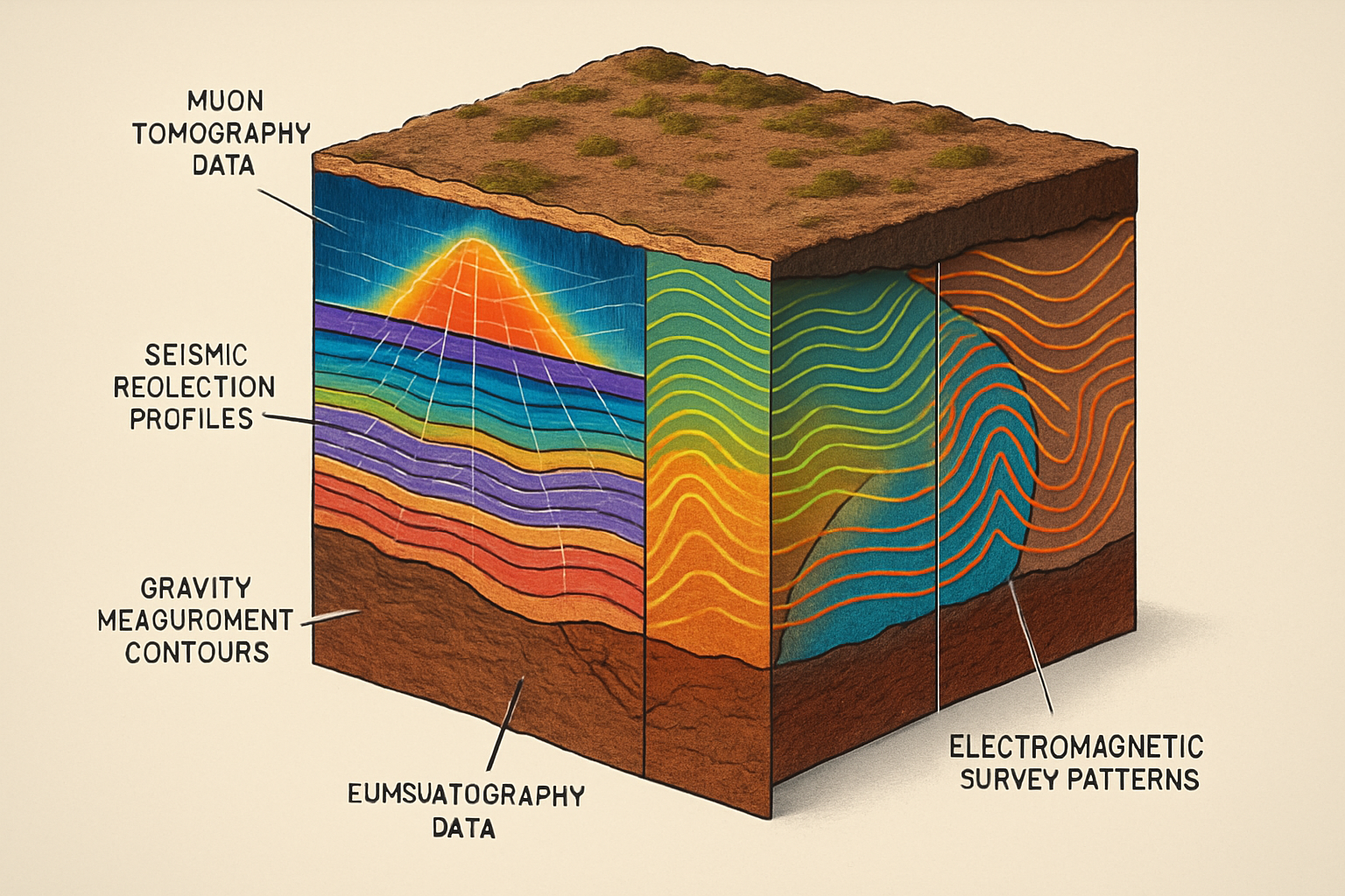
The inherent ambiguities in geophysical inverse problems mean that integrating multiple datasets often yields more robust and reliable subsurface models. Muon tomography provides density information, which is complementary to other geophysical methods like seismic surveys (sensitive to acoustic impedance), gravity surveys (sensitive to bulk density variations), and electromagnetic methods (sensitive to electrical conductivity). For instance, gravity data can provide broad constraints on density anomalies, while muon tomography could offer higher-resolution imaging of specific target zones identified by gravity. Seismic reflection data can delineate structural boundaries, which can then be populated with density estimates from muography. The accurate 3D geological models required for precise muon flux simulations can be improved by incorporating data from techniques like Terrestrial Laser Scanning and UAV Digital Photogrammetry. Such a multidisciplinary approach would be essential for tackling the complexities of deep Earth exploration, allowing for cross-validation of results and a more comprehensive understanding of subsurface structures and resource potential.
Conclusion
Subterranean muon tomography has proven itself as a valuable non-invasive imaging tool for a range of applications, particularly in volcanology, archaeology, and near-surface geophysics. Its ability to map density variations offers unique insights into the internal structure of large objects. The primary challenge for extending its reach to deeper Earth structures and resource deposits is the significant attenuation of muon flux with depth. However, ongoing advancements in detector technology, data acquisition strategies (such as longer exposures, larger detector arrays), and sophisticated image reconstruction algorithms, potentially incorporating AI, hold promise for pushing these depth limits.
Future research should focus on developing more sensitive and cost-effective muon detectors suitable for deployment in harsh deep underground environments. Rigorous pilot studies targeting well-characterized deep geological features or known ore deposits are needed to validate and benchmark the technique's capabilities and limitations at greater depths. The integration of muon data with other geophysical datasets within robust joint inversion frameworks will be critical. While true "deep Earth" imaging on the scale achievable with seismic or neutrino tomography is unlikely for muons, the potential to provide detailed density maps of the upper few kilometers of the crust—a critical zone for resources, tectonics, and groundwater—represents a significant and achievable frontier. Addressing these challenges could unlock new possibilities for mineral exploration, geological hazard assessment, and fundamental Earth science research.
References
- Alonso-Monsalve, S. et al. (2024). Deep-learning-based decomposition of overlapping-sparse images: application at the vertex of simulated neutrino interactions. Communications Physics. https://doi.org/10.1038/s42005-024-01669-8
- Ariga, A. et al. (n.d.). Nuclear Emulsions. Particle Physics Reference Library. https://doi.org/10.1007/978-3-030-35318-6_9
- Beni, T. et al. (2023). Laser scanner and UAV digital photogrammetry as support tools for cosmic-ray muon radiography applications: an archaeological case study from Italy. Scientific Reports. https://doi.org/10.1038/s41598-023-46661-4
- Beni, T. et al. (2023). Transmission-Based Muography for Ore Bodies Prospecting: A Case Study from a Skarn Complex in Italy. Natural Resources Research. https://doi.org/10.1007/s11053-023-10201-8
- Borselli, D. et al. (2022). Three-dimensional muon imaging of cavities inside the Temperino mine (Italy). Scientific Reports. https://doi.org/10.1038/s41598-022-26393-7
- Chiu, I-H. et al. (2025). Nondestructive 3D elemental imaging of Edo’s archaeological artifacts via muonic X-ray measurements. npj Heritage Science. http://dx.doi.org/10.1038/s40494-025-01741-8
- Cimmino, L. et al. (2019). 3D Muography for the Search of Hidden Cavities. Scientific Reports. https://doi.org/10.1038/s41598-019-39682-5
- Gonidec, Y. et al. (2019). Abrupt changes of hydrothermal activity in a lava dome detected by combined seismic and muon monitoring. Scientific Reports. https://doi.org/10.1038/s41598-019-39606-3
- Jäger, T. T. et al. (2025). Characterization of a mock up nuclear waste package using energy resolved MeV neutron analysis. Scientific Reports. http://dx.doi.org/10.1038/s41598-025-89879-0
- Koll, D. et al. (2024). A cosmogenic ^10Be anomaly during the late Miocene as independent time marker for marine archives. Nature Communications. https://doi.org/10.1038/s41467-024-55662-4
- Kumar, A., & Agarwalla, S. K. (2021). Validating the Earth’s core using atmospheric neutrinos with ICAL at INO. Journal of High Energy Physics. https://doi.org/10.1007/JHEP08(2021)139
- Lo Presti, D. et al. (2020). Muographic monitoring of the volcano-tectonic evolution of Mount Etna. Scientific Reports. https://doi.org/10.1038/s41598-020-68435-y
- Nagahara, S. et al. (2022). Three-dimensional density tomography determined from multi-directional muography of the Omuroyama scoria cone, Higashi–Izu monogenetic volcano field, Japan. Bulletin of Volcanology. https://doi.org/10.1007/s00445-022-01596-y
- Nishiyama, R. et al. (2019). Bedrock sculpting under an active alpine glacier revealed from cosmic-ray muon radiography. Scientific Reports. https://doi.org/10.1038/s41598-019-43527-6
- Schumacher, T. et al. (2025). Confirmation of the ScanPyramids North Face Corridor in the Great Pyramid of Giza using multi-modal image fusion from three non-destructive testing techniques. Scientific Reports. http://dx.doi.org/10.1038/s41598-025-91115-8
- Terada, K. et al. (2017). Non-destructive elemental analysis of a carbonaceous chondrite with direct current Muon beam at MuSIC. Scientific Reports. https://doi.org/10.1038/s41598-017-15719-5
- Upadhyay, A. K. et al. (2023). Locating the core-mantle boundary using oscillations of atmospheric neutrinos. Journal of High Energy Physics. https://doi.org/10.1007/JHEP04(2023)068
- Varga, D., & Tanaka, H. K. M. (2024). Developments of a centimeter-level precise muometric wireless navigation system (MuWNS-V) and its first demonstration using directional information from tracking detectors. Scientific Reports. https://doi.org/10.1038/s41598-024-57857-7
- Wen, Q.-G. (2023). Research on rapid imaging with cosmic ray muon scattering tomography. Scientific Reports. https://doi.org/10.1038/s41598-023-47023-w
- Zhang, Z.-X. et al. (2020). Muography and Its Potential Applications to Mining and Rock Engineering. Rock Mechanics and Rock Engineering. https://doi.org/10.1007/s00603-020-02199-9